The final CORONA mission was launched on May 25, 1972. By that
time another satellite program first authorized by President Eisenhower
had achieved success. In 1960, Eisenhower had given the Air Force
permission to go ahead with a program designated GAMBIT. Whereas
CORONA was a search satellite whose mission was to produce photographs
that showed thousands of square miles in a single photograph,
GAMBIT was designed to photograph much narrower swaths of the
earth (only about 120 square nautical miles) but with far greater
resolution. The improved resolution would translate into an ability
to produce better technical intelligence about military facilities,
including nuclear facilities and weapons systems.
In July 1963, the first GAMBIT satellite was launched, carrying
the KH-7 camera system.
Including the final KH-7 mission in June 1967, the GAMBIT/KH-7
program successfully returned imagery on 34 of the 38 missions,
which ranged in duration from one to eight days. Thirty missions
returned usable imagery for analysis. The quality of resolution
improved from about four feet for the initial missions to about
two feet in 1966. (Note 5)
KH-7 imagery allowed U.S. photointerpreters, using the U.S. reactor
at Hanford, Washington, for comparison, to estimate the reactor's
productive capacity. Oblique images of nuclear facilities, particularly
Chinese facilities, were often taken to provide data on the location,
size, and shape of their transformers. The CIA already understood
the capabilities of Soviet transformers, and high-resolution images
of the ones on Chinese facilities would allow superior estimates
of the power going in and the nuclear material coming out. (Note
6)
In 1966, the first of a new generation of GAMBIT satellites would
be launched with a new camera system that would completely supplant
the KH-7 system after the final mission of June 1967. The camera
system for the new generation, the KH-8, would commonly produce
images with a resolution of six inches - and on occasion far better.
While all KH-7 imagery, other than that of Israel, was declassified
in September 2002, no KH-8 imagery has been declassified. All
CORONA imagery was declassified in 1995 and is available at the
National Archives and Records Administration II facility in College
Park, Maryland. All U-2 imagery is also available at NARA II.
Soviet and Chinese nuclear facilities were the most important
targets of U.S. aerial and satellite imagery between 1960 and
1972 and for a number of years beyond. But these were by no means
the only nuclear facilities photographed by U-2 spy planes or
the CORONA and KH-7 satellites. During that period, the nuclear
facilities of France, India, Israel and Taiwan were also targets
of U.S. overhead reconnaissance activities. Specific targets included
nuclear weapons design laboratories, uranium mining facilities,
uranium enrichment and plutonium production plants, nuclear reactors,
and nuclear test sites.
The images presented below represent some examples of the images
obtained between 1960 and 1972. The photographs were located and
extracted from the reels of film held at NARA II by Tim Brown
of Talent-Keyhole.com. Two of these (Image 5 and Image 14) were
obtained specifically for this briefing book, while the others
were collected as part of the research behind the new book, Spying
on the Bomb: American Nuclear Intelligence from Nazi German to
Iran and North Korea, by National Security Archive Senior
Fellow Jeffrey T. Richelson. (Note 7) In addition
to the images, some of the photo interpretation reports for the
target facilities are included in this briefing book.
Images
and Documents
Note: The following documents are in PDF format.
You will need to download and install the free Adobe
Acrobat Reader to view.
Image
1: Tomsk-7, Soviet Union
This photograph of the Tomsk facility in Siberia was obtained
on August 21, 1957, as part of U-2 Mission 4045, part of a group
of missions designated Operation Soft Touch. The images provided
a number of surprises to CIA photointerpreters, revealing, in
addition to the expected uranium enrichment facility, a plutonium-producing
reactor and a plutonium chemical separation facility. (Note
1)
Document
1: Photographic Intelligence Center, Central Intelligence
Agency. Uranium Mining and Milling Complex, Pyatigorsk, USSR,
May 1959. Top Secret [Codeword Redacted]
Source:
CIA Records Search Tool (CREST), National Archives and Records
Administration (NARA) II, College Park, Maryland.
This report, based on U-2 and ground photography, refugee sources,
clandestine reports, and open literature, covers the geology,
the mines and mining activities, and primary processing at the
mines and at the primary processing plant.
Image
2: Arzamas-16, Soviet Union
Construction began on Arzamas-16, the Soviet counterpart to Los
Alamos, in 1946. Located about 250 miles southeast of Moscow and
40 miles south of Arzamas, it became the most secret city in the
Soviet Union, surrounded by fences. First detected through communications
intelligence, it was photographed on February 5, 1960, during
U-2 Mission 8009. (Note 2)
Image
3: Arzamas-16 Explosive Test Cell, Soviet Union
The Explosive Test Cell at Arzamas-16 for testing high-explosives
to be used in nuclear warheads, as photographed on February 5,
1960, during U-2 Mission 8009.
Document
2: National Photographic Interpretation Center, Central Intelligence
Agency. Ancilliary Facilities, Utilities, and Transportation
Networks, Kyshtym, Atomic Energy Complex, USSR, March 1964.
Top Secret.
Source:
CREST, NARA II, College Park, Maryland.
This photographic interpretation report, updates two previous
reports on the same subjects, prepared before KH-7 imagery became
available. The "excellent quality" of the KH-7 imagery
provided "details not previously discernible" and permitted
"an analysis of changes which have occurred in the ancillary
facilities." The facilities covered in the report include
the waste processing facility, a probable fabrication facility,
administration and service area. The report also covers electric
power utilities and transportation facilities.
Document
3: National Photographic Interpretation Center, Central Intelligence
Agency. Kyshtym Atomic Energy Complex, USSR. July 1964.
Top Secret.
Source;
CREST, NARA II, College Park, Maryland.
This report, focusing on the three reactor areas at Kyshtym,
the chemical processing area, and the Tatysh Production Area,
updates reports completed in October, November and December 1963,
and January, February and March 1964. There were six KH-7 missions
from late October 1963 through June 1964, including two after
March 1964. "Extensive refinements" of previous evaluations
were possible, according to the report (p.1), based on the KH-7
imagery.
Document
4: National Photographic Interpretation Center, Probable
Atomic Energy Complex Under Construction Near Chih-Chin-Hsia,
China, [Deleted], August 1964. Top Secret.
Source:
CREST, NARA II, College Park, Maryland
At the time this photographic interpretation report was prepared,
the Jiuquan complex
(see Image 8) was referred to a Chih-Chin-Hsia.
This report indicates the progression of knowledge about the Chinese
program. The summary (p.1) notes that when earlier reports were
prepared "the nuclear implications of the complex were considered
to be only suspect" while "later photography ... indicates
that is a probable atomic energy complex ..." The report
addresses the areas responsible for production, construction support
and storage. It covers the workshop area, the main housing area,
and the clay pit area. It also contains a comparison with other
installations, including Baotou (see Image
10) and Kyshtym (see Document 3).
Document
5: Imagery Analysis Division, Central Intelligence Agency.
Reactor Buildings, Kyshtym and Tomsk Atomic Energy Complexes,
USSR, date not legible, Top Secret.
Source:
CREST, NARA II, College Park, Maryland.
Internal evidence suggests that this report was produced in1964
and was thus able to incorporate imagery produced from several
KH-7 missions. The report, as released, consists largely of photographs
and drawings based on the overhead photography.
Image
4: Tomsk-7, Soviet Union
The Tomsk-7 nuclear facility, as photographed on January 24,
1966 during KH-7 mission January 24, 1966.
Image
5: Trombay, India
Trombay, the site of India's first reactor (Aspara) and a plutonium
reprocessing facility, as photographed by a KH-7/GAMBIT satellite
on February 19, 1966. Trombay is also the home of the Bhabha Atomic
Research Centre (BARC), which was known as the Atomic Energy Establishment
at the time the photograph was taken. (Note 3)
Image
6: Lanzhou Gaseous Diffusion Plant, China
The Lanzhou Gaseous Diffusion Plant, as photographed on May 10,
1966, by a KH-7/GAMBIT satellite during Mission 4028. Early 1960s
U.S. intelligence analyses significantly underestimated Lanzhou's
ability to produce the highly enriched uranium needed for China's
first bomb. (Note 4)
Image
7: Mururoa
The French nuclear test site at Mururoa, in the Pacific, as photographed
by a KH-7/GAMBIT satellite on May 26, 1967. France began testing
its nuclear weapons in 1960 in Algeria. Political pressure from
African states forced France to move its Algerian tests underground,
while Algerian independence forced France to look for an entirely
new test site. The French-controlled atolls of Mururoa and Fangataufa
were selected, and construction began in the mid-1960s. Atmospheric
testing there continued until late 1974. (Note
5)
Image
8: Mururoa
A close-up of the entrance to the test shafts at Mururoa, as
photographed by a KH-7/ GAMBIT satellite on May 26, 1967.
Image
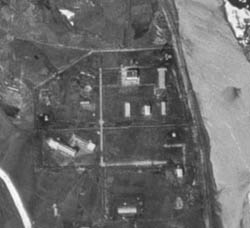
9: Jiuquan Atomic Energy Complex, China.
The Jiuquan Atomic Energy Complex, as photographed on September
22, 1966, by a
KH-7/GAMBIT satellite. Construction began on the facility in August
1959. When completed, it would house a Plutonium Reprocessing
Plant and Nuclear Fuel Reprocessing Plant - the latter for converting
uranium hexafluoride to uranium metal - as well as a Nuclear Component
Manufacturing Plant. (Note 6)
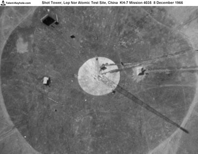
Image
10: Lop Nur Nuclear Test Site, China.
After an extensive search that began in August 1958, Chinese
authorities selected a site in northwestern China - known as Lop
Nur - to test China's nuclear weapons. The first was tested on
October 16, 1964. This shot tower, which would hold a test device,
was photographed on December 8, 1966, during a KH-7/GAMBIT mission.
A test occurred on December 28, 1966.
Image
11: Baotou Nuclear Fuel Component Plant, China
The Baotou Nuclear Fuel Component Plant in central China, as
photographed on June 5, 1967 during KH-7/GAMBIT Mission 4038.
The plant produced uranium tetraflouride, which would be converted
into uranium hexalfluoride and used to produce enriched uranium.
At first, the U.S. Intelligence Community believed that Baotou
was home to a plutonium production facility.
Image
12: Marcoule Plutonium Production Plant, France.
The Marcoule Plutonium Production Plant, France, as photographed
on June 11, 1967 by a KH-7/GAMBIT satellite during Mission 4038.
The plant, designated G-1, went critical on January 7, 1956, and
reached full power in September.
Image
13: Pierrelatte Uranium Enrichment Plant, France
The Pierrelatte Uranium Enrichment Plant, France, photographed
on June 11, 1967, by a KH-7/GAMBIT satellite. In 1958, ground
was broken at Pierrelatte for a gaseous diffusion plant. In July
1963, a special national intelligence estimate, The French
Nuclear Weapons Program, estimated that the facility would
be completed in 1967. (Note 7)
Image
14: Yongbyon, North Korea
Yongbyon, the center of North Korean nuclear research activities,
as photographed on March 17, 1970, by a KH-4B CORONA satellite.
It was first photographed by a CORONA satellite in 1965, the same
year the Soviet Union sold North Korea a small research reactor.
Between 1965 and the end of the CORONA program in 1972, it would
be photographed 36 times. In 1980, a U.S. spy satellite would
detect the components of a nuclear reactor near a large hole at
the site. (Note 8)
Image
15: Dimona, Israel
Israel's Negev Nuclear Research Center, popularly known as Dimona,
during a KH-4B Mission on September 29, 1971. U-2 missions, starting
in early 1958, showed significant construction, including of an
underground facility at a site a dozen miles from Dimona. Israel
initially claimed that the site housed a textile facility. Eventually
it acknowledged the presence of a nuclear facility, but not the
presence of a chemical reprocessing facility nor Dimona's role
in the production of nuclear weapons. (Note 9)
Notes from Essay
1. Chris Pocock, Dragon Lady: The History
of the U-2 Spyplane (Shrewsbury, England: Airlife, 1989),
p27; Gregory W. Pedlow and Donald Welzenbach, The Central
Intelligence Agency and Overhead Reconnaissance: The U-2 and OXCART
Programs, 1954-1974 (Washington, D.C.: Central Intelligence
Agency, 1992), pp. 104-105.
2. Jeffrey T. Richelson, The Wizards of Langley:
Inside the CIA's Directorate of Science and Technology (Boulder,
Co.: Westview, 2001), p. 13.
3. Ibid., pp. 18-19.
4. Derived from Dwayne A. Day, John M. Lodgson,
and Brain Latell (eds.), Eye in the Sky: The Story of the
Corona Spy Satellites (Washington, D.C.: Smithsonian, 1998),
pp. 231-233.
5. National Imagery and Mapping Agency, America's
Eyes: What We Were Seeing (Bethesda, Md.: NIMA, 2002), pp.
2-3.
6. Jeffrey T. Richelson, "A 'Rifle' in
Space," Air Force Magazine, June 2003, pp. 72-75.
7. Jeffrey T. Richelson, Spying
on the Bomb: American Nuclear Intelligence from Nazi Germany to
Iran and North Korea (New York: W.W. Norton, 2006).
Notes
from Documents Annotations
1. Jeffrey T. Richelson, Spying
on the Bomb: American Nuclear Intelligence from Nazi Germany to
Iran and North Korea (New York: W.W. Norton, 2006, pp.
116-119).
2. Ibid., p. 66.
3. Ibid., pp. 206-207.
4. William Burr and Jeffrey T. Richelson, "Whether
to 'Strangle the Baby in the Cradle': The United States and the
Chinese Nuclear Program, 1960-1964," International Security,
25, 3 (Winter 2000/01), pp. 54-99.
5. Richelson, Spying on the Bomb,
pp. 190-191.
6. Burr and Richelson, "Whether to Strangle
the Baby in the Cradle'."
7. Director of Central Intelligence, SNIE 22-2-63,
The French Nuclear Weapons Program, July 24, 1963, pp.
i, 4-5.
8. Richelson, Spying on the Bomb,
p. 330.
9. See Avner Cohen, Israel and the Bomb
(New York: Columbia University Press, 1998).