|
CALM SITE U11A |
IMNAVAIT 1-km GRID |
|
Site code |
U11A |
|
Site name |
Imnavait |
|
CAPS I Metadata form |
GGD359 |
|
CAPS II Metadata form |
GGD313U_11 |
|
Responsible for data submission |
Nikolay
Shiklomanov |
|
Email Address |
shiklom”-at-“gwu.edu |
|
Institution/Organization |
GWU |
|
Location description |
Arctic Alaska |
|
Location Lat. |
68 deg. 30 min. N |
|
Location Lon. |
149 deg. 30 min. W |
|
Elevation avg. (m) |
910 |
|
Methods Grid |
1000 |
|
Methods Other |
Air Temperature, Soil temperature, Soil Moisture |
|
Landscape Description |
Glaciated
foothills |
|
Vegetation /Classification |
Tussock-graminoid, dwarf- shrub tundra and low-shrub tundra
(moist acidic) |
|
Soils (or Material) |
Typic Histoturbel,
Typic Aquorthel |
|
Thaw depth measurements (year started)
|
1993 |
|
Air temp. measurements (year started) |
1986 |
|
Snow cover measurements (year started) |
NA |
|
Soil temp. measurements (year started) |
1986 |
|
soil moisture measurements (year started) |
NA |
|
general description of soil moisture (dry, moist, wet,
saturated) |
Dry on top
of the ridges, wet to saturated in the valley |
|
soil texture: if non organic describe texture, if organic indicate
thickness of organic layer (cm) |
Organic
Layer thikness:10 (cm); mineral texture -- silty
loam /loam/gravelly loam (coarce glacial till) |
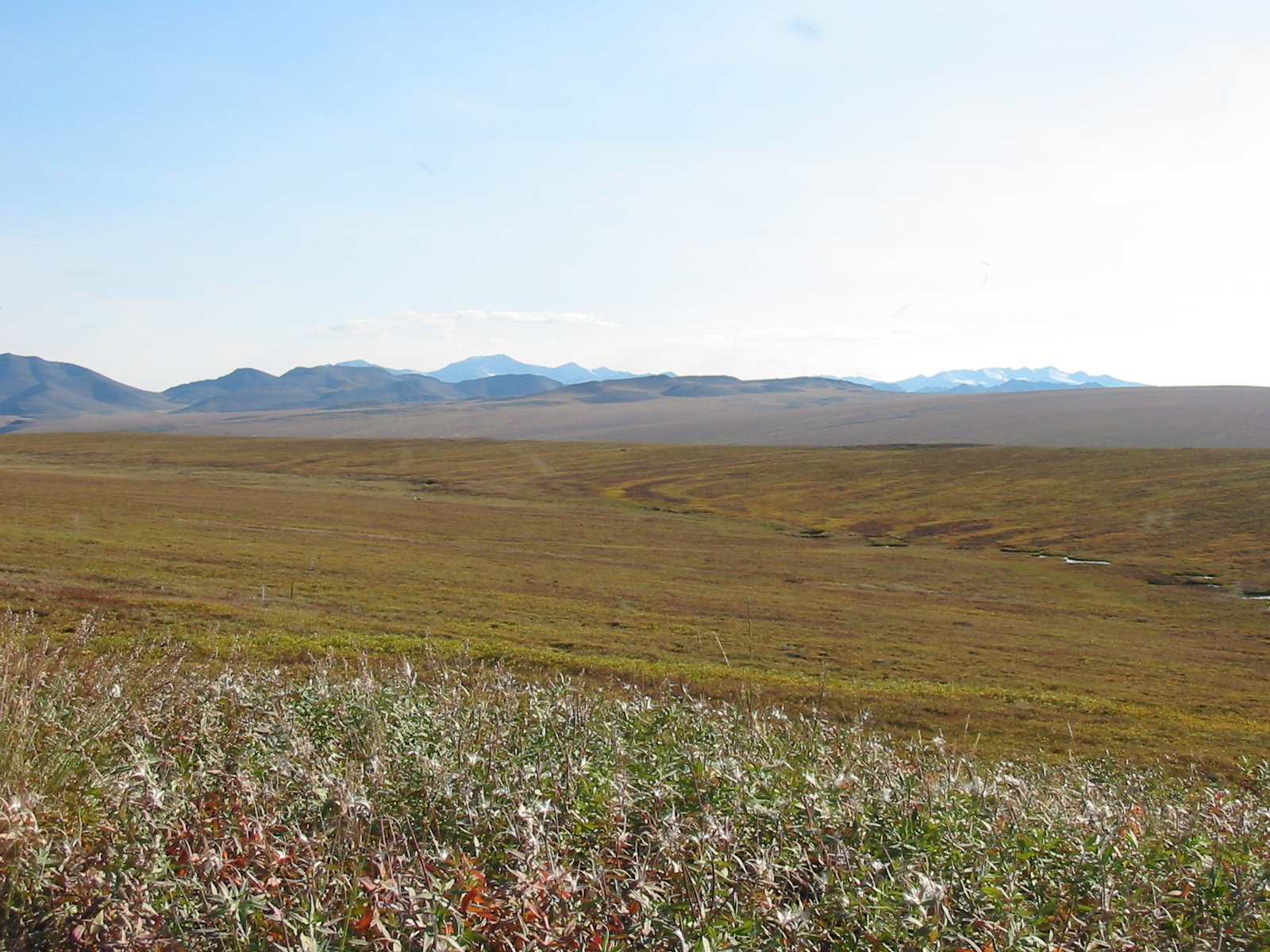
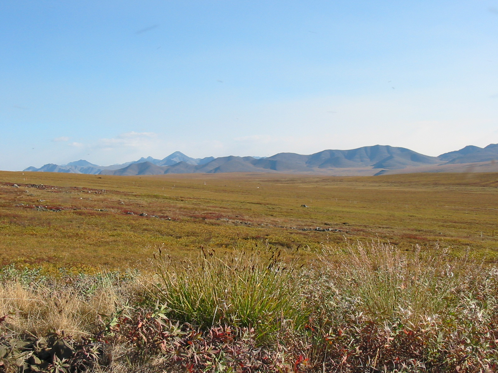
DESCRIPTION OF AREA CONTAINING SITE:
The Imnavait
Creek site encompasses a north-south trending stream valley, much of the
valley’s slopes, and an adjoining hill crest. Wet acidic tundra with a
thick organic mat occupies the valley bottom. The higher elevations are
occupied by moist acidic tundra, but the slopes are broken by numerous water
tracks that become more prominent downslope (McNamara et al., 1999). These
narrow zones contain shrub vegetation, especially
willow (Hinkel & Nelson, 2003).
SOIL DESCRIPTION:
(predominant texture, i.e., ‘sand’, ‘gravel’,
‘peat’, etc.): Typic Aquiturbel
(Upland), Typic Hemistel
(Lowland)
SAMPLING DESIGN AND METHOD:
1-sq km grid consists of a square
array of surveyed permanent stakes separated by 100 m, yielding an 11 ×
11 array of sampling nodes on each grid. Thaw depth and snow sampling was conducted
twice by manual probing at each stake. The two values for each sampling point
are averaged, yielding a maximum of 121 data points per grid per probing date.
The active layer was not measured at locations where grid points intersect
rocks or deep water.
REFERENCES:
Hinkel, K.M. & Nelson, F.E. 2003. Spatial
and temporal patterns of active layer thickness at Circumpolar Active Layer
Monitoring (CALM) sites in northern Alaska, 1995-2000.
Journal of Geophysical Research, Vol.108, No. D2, 8168.
McNamara, J. P., D. L. Kane, and L. D. Hinzman.
1999. An analysis of an arctic channel network using a digital elevation model,
Geomorphology, 29,339–353.
Shiklomanov, N.I. and F.E. Nelson. 2003 Climatic variability in the Kuparuk region, north-central Alaska: optimizating
spatial and temporal interpolation in a sparse
observation network. Arctic,
56: 136-146.
Shiklomanov, N.I. and F.E. Nelson. 2003 Statistical representation of
landscape-specific active-layer variability. In Phillips, M., Springman,
S. M., and Arenson, L. U. (eds.), Proceedings of
the Eighth International Conference on Permafrost, vol. 2. Lisse: A.A. Balkema, 1039-1044.
Walker
D.A., Jia G.J., Epstein H.E., Raynolds
M.K., Chapin III F.S., Copass C., Hinzman
L.D., Kane D., Knudson J.A., Maier H., Michaelson
G.J., Nelson F.E., Ping C.L., Shiklomanov N.I.,
Romanovsky V.E., Shur
Y. 2003 Vegetation-soil-thaw-depth
relationships along a Low Arctic bioclimatic gradient, Alaska: Synthesis of
information from the Atlas studies. Permafrost and Periglacial
Processes, 14: 103-123.
Shiklomanov
N. I. and F. E. Nelson, F. E., 2002.
Active-layer mapping at regional scales: a 13-year spatial time series for the Kuparuk region, north-central Alaska. Permafrost and Periglacial Processes, 13:
219-230.
Klene A.E., Nelson F.E., and N.I. Shiklomanov.
2001 The n-factor as a tool
in geocryological mapping: seasonal thaw in the Kuparuk River Basin, Alaska. Physical
Geography, 22(6): 449-466.
Klene A.E., Nelson F.E., Shiklomanov
N.I., and K.M. Hinkel.
2001 The n-factor in natural
landscapes: Variability of air and soil-surface temperatures, Kuparuk River basin, Alaska. Arctic,
Antarctic and Alpine Research, 33(2): 140-148.
Nelson, F.E., Shiklomanov, N.I., and
G.R. Mueller. Variability of active-layer thickness at multiple spatial scales,
north-central Alaska, USA. 1999 Arctic, Antarctic, and Alpine Research, 31(2): 179-186.
Shiklomanov, N.I. and F.E. Nelson. Analytic
representation of the active layer thickness field, Kuparuk
River basin, Alaska. 1999 Ecological
Modelling, 123: 105-125.
Bockheim, J.G., Walker,
D.A., Everett, L.R., Nelson, F.E. and N.I. Shiklomanov. 1998 . Soils and
cryoturbation in moist nonacidic and acidic tundra in the Kuparuk
River basin, Arctic Alaska, USA. Arctic
and Alpine Research, 30(2): 166-174.
Nelson, F.E., Hinkel, K.M.,
Shiklomanov, N.I., Mueller, G.R., Miller, L.L., and D.A.
Walker.
Active-layer thickness in north central Alaska: systematic sampling, scale, and
spatial autocorrelation. 1998
Journal of Geophysical Research-Atmospheres, 103(D22): 28963-28973.
Nelson, F.E., Outcalt, S.I.,
Brown, J., Shiklomanov, N.I., and K.M. Hinkel.
Spatial and temporal attributes of the active-layer thickness record, Barrow,
Alaska, USA, 1998 Proceedings of the Seventh International
Conference on Permafrost. Centre de etudes nordiques
de l'Universite Laval, Laval, Quebec, Canada,
Yellowknife, NWT, Canada, pp. 797-802
Walker,
D.A., Auerbach, N.A., Bockheim,
J.G., Chapin, F.S., Eugster, W., King, J.Y., McFadden,
J.P., Michaelson, G.J., Nelson, F.E., Oechel, W.C., Ping, C.L., Reeburg,
W.S., Regli, S., Shiklomanov, N.I., and G.L.
Vourlitis.1998 Energy and trace-gas fluxes across a soil pH boundary in the
arctic. Nature, 394(6692): 469-472.
Nelson
F.E., Shiklomanov, N.I., Mueller G.R., Hinkel K.M., Walker D.A., and J.G.
Bockheim.1997 Estimating active-layer thickness over a large region: Kuparuk River basin, Alaska, USA. Arctic and Alpine Research, 29(4): 167-378.
Additional climate snow and hydrologic
data are also available at http://www.uaf.edu/water/projects/NorthSlope/imnavait/imnavait.html