|
CALM SITE R9 |
CAPE ROGOZHNY |
|
|
Site code |
R9 |
|
|
Site name |
Cape Rogozny |
|
|
CAPS I Metadata form |
GGD347 |
|
|
CAPS II Metadata form |
GGD347_R9 |
|
|
Responsible for data submission |
Anatoly Kotov (till 2007), Volodya Razzhivin (2007-) |
|
|
Email Address |
VolodyaR”-at-“north.bin.ras.spb.ru |
|
|
Institution/Organization |
Komarov Botanical Institute RAS, St.
Petersburg |
|
|
Location description |
Chukotka |
|
|
Location Lat. |
64 deg. 47
min. N |
|
|
Location Lon. |
176 deg. 58
min. E |
|
|
Elevation avg. (m) |
17 |
|
|
Methods Grid |
100 |
|
|
Methods Other |
Air Temperature, Soil temperature |
|
|
Landscape Description |
Hilly plain |
|
|
Vegetation /Classification |
Mesic dwarf shrub-cottongrass-moss
tussock tundra |
|
|
Soils (or Material) |
Gleyi-Histic Cryosols
(loamy) |
|
|
Thaw depth measurements (year
started)
|
1994 |
|
|
Air temp. measurements (year
started) |
1996 |
|
|
Snow cover measurements (year
started) |
||
|
soil
temp. measurements (year started) |
1996 |
|
|
soil moisture measurements (year
started) |
||
|
general description of soil moisture
(dry, moist, wet, saturated) |
moist |
|
|
soil texture: if non organic
describe texture, if organic indicate thickness of organic layer (cm) |
sandy loam |
|
|
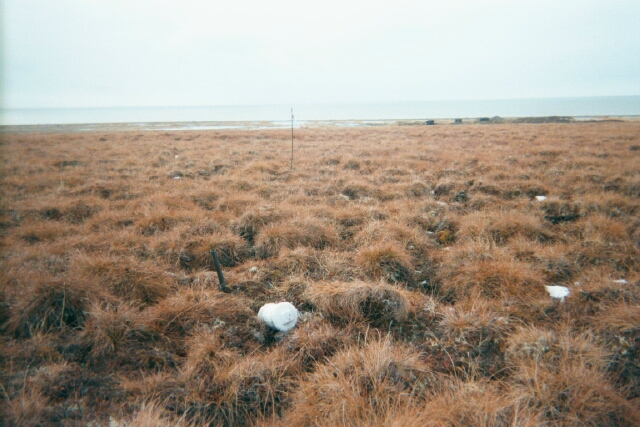
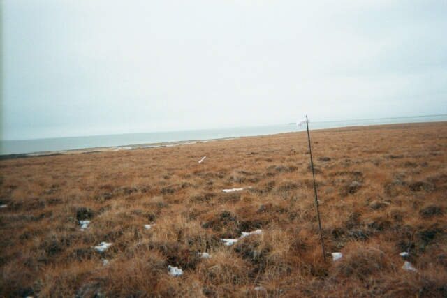
SITE DESCRIPTION The grid “Cape Rogozhny”,
100x100 m, is located on Lower-Anadyr (Nizhneanadyrskaya)
Lowland at the northern coast of Onemen bay (64°47¢ North and 176°58¢ East). Relief of the area is hilly
plain with altitudes 5 to 30 m above the water level in the Bay. CALM grid is
set at the flat hilltop slightly (at 0-3o) inclined
southwestward. The surface is represented by typical hummocky-moss tundra.
Hummocks are formed of cotton grass (Erioophorum vaginatum)
dominating throughout the plain. Hummock height is 15-20 cm. They cover 60 to
70% of the surface, the rest occupied by inter-hummock depressions filled
mostly by green and bog mosses (Sphagnum
sp.sp.) with admixture of lichens. Coverage of the
dwarf shrubs within the grid is 30-40 %; coverage of green moss is 20-30 %
and of lichens – 5 to 10%. Main producer of ground-level phytomass is cotton grass. The grid is located in the area of transition from
moderately-continental to marine climate subzone of the SubArctic
climatic zone. Mean annual air temperature at Anadyr weather station (30 km
from the grid) is -7,7oС, mean annual precipitation is 312
mm. The hydrochemical conditions
of the grid in many respects are instituted by closeness of marine coast. The
type of atmospheric precipitation here is transitional from maritime to
continental. Rain and thawed snow water are of chloride-hydrocarbon-sodium
type with mineralization up to 45 mg/l. At inflow of thawed and rain waters
into the active layer, they get saturated by ions of calcium, magnesium and hydrocarbonate, the mineralization rise up to 80-88 mg/l. The grid is located in the continuous permafrost area. Taliks of hydrogenous type are found only below the Onemen Bay and large lakes. Mean annual ground
temperature is about –5oC, the permafrost thickness is up to
150 m. Frost cracks and ice-wedge, and spot-medallion formation are periglacial features developed within the grid. At the
adjacent area, the coastal processes are widespread: coastal thermoerosion, thermocircues
connected with massive ground ice occurrence. Cryolithological
structure of permafrost is variable. Immediately beneath the active layer
modern and Holocene ice wedges are lying, up to 2 m wide and up to 3 m high.
In fine-grained sands of Late-Pleistocene age syngenetic
ice wedges are tracked up to 2 m in width, with vertical expansion up to 20
m. Besides, the syngenetic sandy and sandy-ice
wedges are observed. In the lower stratigraphic glacial complex massive
ground ice is widely distributed. SOIL
DESCRIPTION: (predominant texture, i.e.,
‘sand’, ‘gravel’, ‘peat’, etc.): Soils of grid are peaty-gley with poorly developed (up to 10, rarely to 20 cm)
organic horizon underlain by peaty silt. Below fine-grained sands of
Late-Pleistocene age up to 20 m thick are found, which in their turn are
underlain by glacial till of Middle-Pleistocene age. |
|
|
SAMPLING DESIGN AND METHOD:
Permanent
100x100 m grids have been established, with 10-m intervals between grid nodes.
Thaw depths were determined at each grid node (121) using a steel rod. The measurements
of the active-layer thickness were performed in inter-hummock depressions
according to the CALM procedure from 1994 to present. At the site a surface quality of
microhabitats such as tundra, vehicle tracks, frost boils etc. was estimated.
The site is supplied with a temperature data-loggers measuring air and soil
temperatures to the depth of 100 cm but measurements are irregular (see Temperature folder)
REFERENCES:
Zamolodchikov,
D.G., Kotov, A.N., Karelin,
D.V. & Razzhivin, V.Y. 2004. Active-Layer Monitoring in Northeast Russia: Spatial, Seasonal, and Interannual Variability. Polar Geography 28 (4): 286-307.
Zamolodchikov D., A. Kotov,
D. Karelin, and V. Razzhivin. 2008. Recent Climate and Active Layer Changes
in Northeast Russia: Regional Output of Circumpolar Active Layer Monitoring
(CALM). Proceedings of
the 9th International Conference on Permafrost, Fairbanks, Alaska, June 29 -
July 3, 2008, Vol. 2, 2021-2026.