|
CALM SITE R2 |
AYACH-YAKHA |
|
Site code |
R2 |
|
Site name |
Ayach-Yakha
|
|
CAPS I Metadata form |
GGD345 |
|
CAPS II Metadata form |
GGD313_R2 |
|
Responsible for data submission |
Dmitry Kaverin |
|
Email Address |
dkav”-at-“mail.ru |
|
Institution/Organization |
Institute
of Biology, Komi Center RAS, Syktyvkar |
|
Location description |
European
North of Russia |
|
Location Lat. |
67 deg. 35
min. N |
|
Location Lon. |
64 deg. 11
min. E |
|
Elevation avg. (m) |
148 |
|
Methods Grid |
100 |
|
Methods Other |
Air Temperature, Soil temperature, Soil Moisture, Snow Depth,
Frost heave and Thaw settlement |
|
Landscape Description |
Shallow,
glacial marine deposit over bedrock, dissected by streams |
|
Vegetation /Classification |
Mesic dwarf shrub-moss tundra with frost
boils |
|
Soils (or Material) |
Turbi-Histic (Gleyic),
Gleyi-Turbic Cryosols
(loamy) |
|
Thaw depth measurements (year started)
|
1999 |
|
Air temp. measurements (year started) |
1947 |
|
Snow cover measurements (year started) |
2001 |
|
soil
temp. measurements (year started) |
1999 |
|
soil moisture measurements (year started) |
1999 |
|
general description of soil moisture (dry, moist, wet,
saturated) |
Moist |
|
soil texture: if non organic describe texture, if organic
indicate thickness of organic layer (cm) |
12 |
SITE
DESCRIPTION
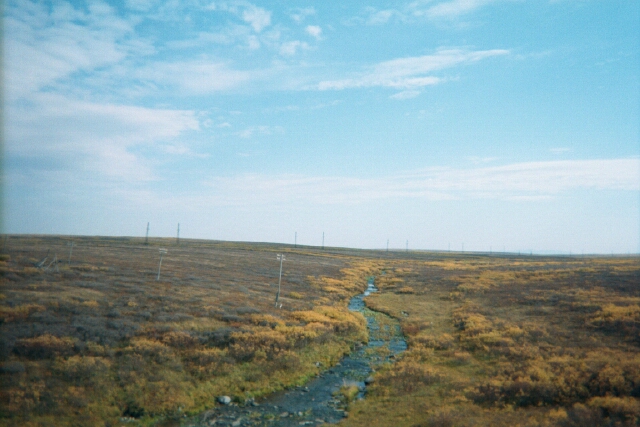
The
Ayach-Yakha CALM site (67 35.40N; 64 09.90E) is
located near the town of Vorkuta, 400 km to the east of Bolvansky
grid. MAAT at the Vorkuta weather station is 5.9 C and precipitation is 550 mm
(1948–2002). The Ayach-Yakha grid is located 13 km northeast of the town of
Vorkuta on an undulating plain covered with silty
loam of glacial-marine origin. The grid occupies a gentle (3 deg.)
southwest-facing slope with a creek flowing within 20 m of its lower border.
The range of elevations within the site is 5 m. Schist bedrock is exposed in
the creek valley. At the two lowest tiers of the grid the loamy deposit is
about 120–150 cm thick over the bedrock. Dwarf shrub/feather moss tundra
with numerous frost boils occupies the site. Some dwarf birch and willow
thickets are up to 50 cm high. Soil organic layer thickness ranges from 0 to 25
cm, with a site average of 12 cm. Soils are gleyed and thixotropic, with cryoturbation best developed
under and around frost boils. The soils are classified as Turbi-Histic
(Gleyic) and Gleyi-Turbic Cryosols (Mazhitova et al.,
2004).
SOIL DESCRIPTION:
(predominant texture, i.e., ‘sand’, ‘gravel’,
‘peat’, etc.): Dystri Turbi-Histic
(Gleyic), Gleyi-Turbic Cryosols (loamy)
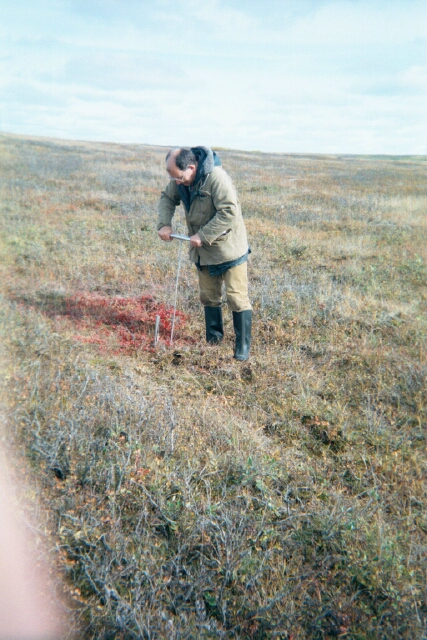
SAMPLING DESIGN AND METHOD:
1-ha grid
consists of a square array of surveyed permanent stakes separated by 10 m,
yielding an 11 × 11 array of sampling nodes on each grid. Thaw depth
sampling was conducted four times by manual probing at each stake. The four
values for each sampling point are averaged, yielding a maximum of 121 data
points per grid per probing date. Snow depths are measured at each grid
node annually in April. Volumetric water content in the surface soil horizon is
determined for each grid node annually at the end of the warm season. Water
content is determined several times during the season by portable Vitel Hydra® probe. Air temperatures at a height of 2
m, as well as soil and upper-permafrost temperatures are recorded with the use
of miniature Onset data loggers. Ground subsidence and/or heave are determined
at Ayach-Yakha for each grid node annually at the
beginning and at the end of the warm season with the use of a 2H-10KL leveling
instrument (Russia) providing for 4 mm accuracy.
REFERENCES:
Mazhitova G., Malkova (Ananjeva)
G., Chestnykh O., Zamolodchikov
D. 2004. Active-layer
spatial and temporal variability at European Russian
Circumpolar-Active-Layer-Monitoring (CALM) sites. Permafrost and Periglacial Processes,15. P.
123–139.
Mazhitova, G.G. & Kaverin, D.A. 2007.
Thaw depth dynamics and soil surface subsidence at a Circumpolar
active layer monitoring (CALM) site, the European north of Russia. Kriosfera Zemli XI(4): 20-30.
Mazhitova,
G.G. et al. 2008. Recent Decade
Thaw-Depth Dynamics in the European Russian Arctic,
Based on the Circumpolar Active Layer Monitoring (CALM) Data. Proceedings of the Ninth International
Conference on Permafrost, Fairbanks, Alaska, Vol. 2, 1155-1160