|
CALM SITE R11 |
MT. DIONISIYA |
|
Site code |
R11 |
|
Site name |
Mountain Dionisiya |
|
CAPS I Metadata form |
|
|
CAPS II Metadata form |
GGD313_R11 |
|
Responsible for data submission |
Volodya Razzhivin |
|
Email Address |
VolodyaR”-at-“north.bin.ras.spb.ru |
|
Institution/Organization |
Komarov Botanical Institute RAS, St.
Petersburg |
|
Location description |
Chukotka |
|
Location Lat. |
64 deg. 34
min. N |
|
Location Lon. |
177 deg. 12
min. E |
|
Elevation avg. (m) |
148 |
|
Methods Grid |
100 |
|
Methods Other |
Soil Temperature |
|
Landscape Description |
Proluvial-deluvial mountain foot |
|
Vegetation /Classification |
Mesic sedge-dwarf shrub-moss hummocky
tundra with cottongrass tussock |
|
Soils (or Material) |
Gleyi-Histic Cryosols
(loamy) |
|
Thaw depth measurements (year started)
|
1996 |
|
Air temp. measurements (year started) |
1997 |
|
Snow cover measurements (year started) |
|
|
soil
temp. measurements (year started) |
1997 |
|
soil moisture measurements (year started) |
|
|
general description of soil moisture (dry, moist, wet,
saturated) |
moist |
|
soil texture: if non organic describe texture, if organic
indicate thickness of organic layer (cm) |
sandy loam,
some peat |
|
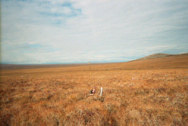
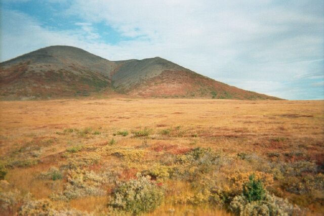
SITE DESCRIPTION «Mt.
Dionisiya» CALM site (100 ´
100 m) is situated in Nizhneanadyrskaya Lowland in
the bottom of western slope of Mt. Dionisiya (N 64°34¢31²,
E 177°11¢37²). The site is
located 25 km south of Anadyr city and is 35 km from the Cape Rogozhny site.
The area belongs to subarctic climatic belt with transitional climate from
moderately continental to marine one. According to Anadyr City weather
station (25 km NNE from the site) the average annual air temperature is
-7,7ºС, average annual precipitations are 312 mm. Remarkable short
period deviations of both annual and monthly average air temperatures and
precipitations are in common.
The site is located in the area of continuous permafrost
with local hydrogenous taliks. Average annual
permafrost temperature is about -5º С; permafrost thickness
reaches 150 m. Cryogenic crumbly-loamy bare ground patches (frost boils)
formation is widely distributed in mountain bottom and plain throughout the Nizhneanadyrskaya Lowland.The
study site is geomorphologically a slightly
inclined (5-6º WSW) proluvial-deluvial
mountain bottom with elevation about 140-145 m a.s.l.
(folder with photos). The site is vegetated by dynamically related set of moist sedge-cotton
grass (Carex stans,
Eriophorum polystachyon,
E. scheuchzeri) stands, which coincide a
network of slowly flowing water tracks, wet to mesic
cotton grass tussock-moss (Eriophorum vaginatum, Sphagnum and non-Sphagnum mosses)
tundra with dwarfshrubs (Betula
exilis, Salix pulchra, Vaccinium uliginosum subsp.
microphyllum, V. vitis-idaea
var. minus, Empetrum subholarcticum,
Ledum decumbens),
which occupy most of the site, and some hillocks (1 to 4 m in diameter and
0.4-0.6 m high from the running water level) with mesic
to xeric dwarfshrub-moss-lichen tundra (Ledum decumbens, Rubus chamaemorus, Arctous alpina, Betula exilis, Vaccinium vitis-idaea var. minus,
V. uliginosum subsp. microphyllum,
Empetrum subholarcticum, Dicranum sp. sp., Polytrichum
sp. sp., Cetraria sp. sp., Cladina
sp. sp., Cladonia sp. sp.) SOIL DESCRIPTION:
(predominant texture, i.e., ‘sand’, ‘gravel’,
‘peat’, etc.): Gleyi-Histic Cryosols (loamy) |
|
SAMPLING DESIGN AND METHOD:
Permanent
100x100 m grid has been established, with 10-m intervals between grid
nodes. Thaw depths were determined at each grid node (121) using a steel rod.
Thaw depth measurements were made in between of tussocks or in lowerings according to the standard CALM procedure from
1996 to present
except for 2006. The relative areas occupied by tundra vegetation, water
tracks, and frost boils were determined, accompanied by grid leveling. The site
is supplied with a temperature data-loggers measuring air and soil temperatures
to the depth of 100 cm but measurements
are irregular (see raw data in the “temperature”
folder)
REFERENCES:
Zamolodchikov,
D.G., Kotov, A.N., Karelin,
D.V. & Razzhivin, V.Y. 2004. Active-Layer Monitoring in Northeast Russia: Spatial, Seasonal, and Interannual Variability. Polar Geography 28
(4): 286-307.
Zamolodchikov D., A. Kotov,
D. Karelin, and V. Razzhivin. 2008. Recent Climate and Active Layer Changes in
Northeast Russia: Regional Output of Circumpolar Active Layer Monitoring
(CALM). Proceedings of
the 9th International Conference on Permafrost, Fairbanks, Alaska, June 29 -
July 3, 2008, Vol. 2, 2021-2026.