|
CALM SITE C1 |
ALEXANDRIA FIORD |
|
Site code |
C1 |
|
Site name |
Alexandria Fiord |
|
CAPS I Metadata form |
GGD341 |
|
CAPS II Metadata form |
GGD313C_1 |
|
Responsible for data submission |
Greg Henry |
|
Email Address |
ghenry”-at-“geog.ubc.ca |
|
Institution/Organization |
University of British Columbia, Vancouver |
|
Location description |
Arctic Islands |
|
Location Lat. |
78 deg. 53 min. N |
|
Location Lon. |
75 deg. 55 min. W |
|
Elevation avg. (m) |
30 |
|
Name code |
[1] |
|
Methods Grid |
100 |
|
Methods Other |
DELETE P |
|
Landscape Description |
High arctic lowland, glacial outwash plain |
|
Vegetation /Classification |
Dwarf Shrub Heath, dominated by Cassiope
tetragona |
|
Soils (or Material) |
Orthic
Eutric Static Cryosol (2) |
|
Thaw depth (year started) |
1996 |
|
soil
temp. measurements (year started) |
|
|
soil moisture measurements (year started) |
|
|
general description of soil moisture (dry, moist, wet,
saturated) |
|
|
soil texture: if non organic describe texture, if organic
indicate thickness of organic layer (cm) |
|
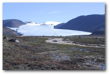
DESCRIPTION OF AREA CONTAINING SITE:
The site is located at Alexandra
Fiord on the east-central side of Ellesmere Island, Nunavut, Canada at 78.54N
75.55W, 30 m elevation asl.
The site was established as part of the International Tundra Experiment (ITEX) project.
SAMPLING DESIGN AND METHOD:
100-m grid consists of a square
array of surveyed permanent stakes separated by 10 m. Sampling was conducted by
manual probing at each stake. The active layer was not measured at locations
where grid points intersect rocks or large water ponds.
For other data and information refer
to ITEX webpage: http://www.geog.ubc.ca/itex/