|
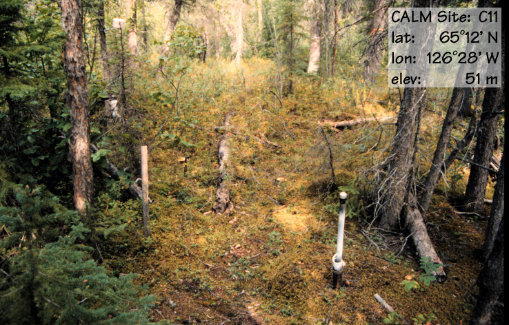
Site code |
C11A |
C11B |
|
Site name |
Norman
Wells (TT) |
Norman
Wells (Grid) |
|
CAPS I
Metadata form |
GGD353 |
|
|
CAPS II
Metadata form |
GGD313C_11A |
GGD313C_11B |
|
Responsible
for data submission |
F. Mark
Nixon |
F. Mark
Nixon |
|
Email
Address |
mnixon@nrcan.gc.ca |
mnixon@nrcan.gc.ca |
|
Institution/Organization |
Geological
Survey of Canada, Ottawa |
Geological
Survey of Canada, Ottawa |
|
Location
description |
Mackenzie
Valley |
Mackenzie
Valley |
|
Location
Lat. |
65 deg. 12
min. N |
65 deg. 12
min. N |
|
Location
Lon. |
126 deg. 28
min. W |
126 deg. 28
min. W |
|
Elevation
avg. (m) |
51 |
52 |
|
Name code |
[3] |
[3] |
|
Methods
Grid |
100 |
|
|
Methods
Other |
TT |
|
|
Years of
record (a) |
10 |
5 |
|
Min Thaw
(cm)(b) |
59 |
45 |
|
Max Thaw
(cm)(b) |
66 |
50 |
|
Thawing
Degree Days (c) |
1429 |
1429 |
|
Landscape
Description |
Fluvial
terrace on till |
|
|
Vegetation
/Classification |
Mixed
spruce forest-feathermoss |
|
|
Soils (or
Material) |
Histic
Eutric Turbic Cryosol (2) |
|
|
soil temp.
measurements (year started) |
1994 |
|
|
soil
moisture measurements (year started) |
1998 |
1999 |
|
general
description of soil moisture (dry, moist, wet, saturated) |
moist |
moist |
|
soil
texture: if non organic describe texture, if organic indicate thicknesss of
organic layer (cm) |
sandy silt
(30 cm) |
sandy silt
(30 cm) |