The ability of the United States to gather overhead imagery of
targets in foreign nations has evolved dramatically over the last
sixty years. Modified bombers and fighters used in World War II
and the early years of the Cold War gave way to specialized reconnaissance
aircraft, such as the U-2 and SR-71, and to a variety of satellite
systems. The capabilities of satellite systems have also evolved
dramatically over the last four decades - from satellites that
returned film days or weeks after the images were obtained to
satellites that return their imagery virtually instantaneously.
In addition, the details that could be extracted from those images
has also risen sharply over the years, as the resolution of the
imagery produced by the satellites has improved dramatically.
(Note 1)
Today the United States maintains a variety of aerial and space
systems that yield imagery of foreign territory. Aerial systems
included manned aircraft such as the U-2 as well as the as the
Predator and Global Hawk unmanned aerial vehicles (UAVs). Space
systems include the advanced KH-11 electro-optical satellites,
the ONYX radar imagery satellite, and, possibly, one or more MISTY
stealth satellites. (Note 2)
Not only has there been an evolution in the capabilities of U.S.
overhead imagery systems, but there has also been an evolution
of policy with regard to the public release of such imagery -
particularly with regard to the release of satellite imagery.
At one time, the very "fact of" satellite reconnaissance
was classified. Despite the acknowledgment of a satellite reconnaissance
effort in 1978 and the existence of the National Reconnaissance
Office in 1992, it was not until 1995 that the U.S. first released
imagery obtained by the CORONA satellites that operated during
the 1960-1972 period as well as images obtained by the ARGON and
LANYARD systems that operated in the early 1960s. (Note
3)
The Clinton administration, on occasion, released imagery obtained
by advanced KH-11 satellites, although in degraded form - so as
not to reveal the full capabilities of the satellites, particularly
their resolution. The selective releases were associated with
U.S. military operations - including strikes against terrorist
training camps in Afghanistan and a pharmaceutical factory in
the Sudan (in response to the attacks on the U.S. embassies in
Kenya and Tanzania), strikes against Yugoslavian targets in support
of U.S. operations in the Balkans, and the air strikes against
Iraqi targets that constituted Operation Desert Fox. The images
released were those used by Pentagon briefers to illustrate U.S.
aerial attacks and their consequences. (Note 4)
From the fall of 2002 through April 2003, the White House, Defense
Department, and State Department released over seventy images,
most obtained by satellite, of portions of Iraq. One objective,
in the time before the beginning of military operations, was to
provide evidence to support U.S. claims about the nature of Saddam
Hussein's regime as well as claims about Iraq's failure to comply
with U.N. resolutions concerning its weapons of mass destruction
programs. Once military operations began, Defense Department and
Central Command briefings made extensive use of overhead, including
satellite, imagery to provide pre- and post-attack views of targets
attacked by coalition air forces.
The overhead imagery presented here is a selection of pre-war
and wartime imagery, and falls into six categories: presidential
and other palaces; weapons of mass destruction sites; other military
targets; command, control, and communications sites; security
and guard facilities; and civilian sites.
Imagery of Presidential Palaces and VIP Facilities
Saddam's numerous presidential palaces, reportedly more than
50, were used by the Bush administration to illustrate their argument
that Iraq's president was diverting resources that belonged to
the Iraqi people to support an exceedingly ostentatious life style.
There was also concern that they might be used to conceal documentation
concerning Iraqi weapons of mass destruction programs, and the
U.N. inspection regime that commenced in late 2002 provided for
inspections of such facilities.
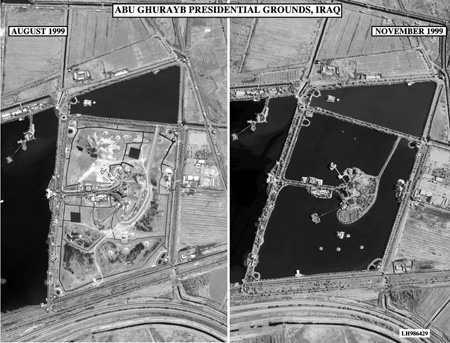
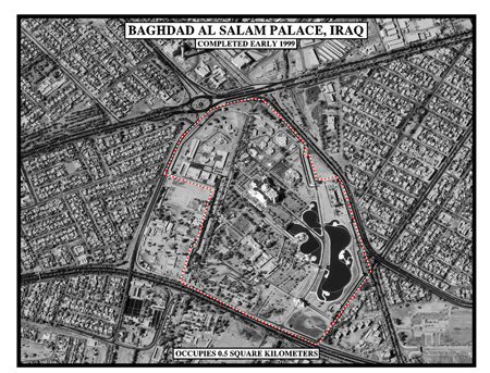
Image 1 and Image
2 show two presidential palaces in Baghdad - Abu Ghurayb
(located near what is now Baghdad International Airport), and
Al-Salam, which was built over the site of a Republican Guards
headquarters that was destroyed during the first Gulf War (and
where after the fall of the regime "locals tossed grenades
in [the] ponds ... and set fire to the main house"). Image
3, which appeared in the 1999 State Department publication,
Saddam Hussein's Iraq, shows Saddamiat al Tharthar, an
extensive lakeside vacation resort, located 85 miles west of Bahgdad.
Its grounds contain stadiums, an amusement park, special hospitals,
and over 600 homes for government officials. (Note
5)
Image 1: Abu Ghurayb Presidential Grounds
Image 2: Baghdad Al Salam
Image 3: Saddamiat al Tharthar
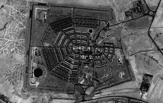
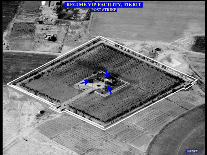
The final two images are pre-and post strike images of a VIP
facility in Tikrit, Saddam Hussein's ancestral home.
Image 4: Regime VIP Facility, Tikrit:
Pre-Strike
Image 5: Regime VIP Facility, Tikrit:
Post-Strike
Weapons of Mass Destruction Sites
The rationale for U.N. inspections of Iraqi facilities, and then
for U.S. military action, was the concern that despite the disarmament
commitment it made at the conclusion of the 1991 Persian Gulf
War, Iraq was not in full compliance -- that it continued to maintain
the infrastructure and programs to produce weapons of mass destruction
and was reconstituting those programs following the departure
of U.N. inspectors in late 1998.
In the fall of 2002, at the same time that the U.S. brought its
concerns to the U.N. Security Council and argued that action needed
to be taken to completely eliminate Iraqi holdings of, and its
ability to produce, WMD, the CIA released an unclassified version
of its new National Intelligence Estimate on Iraqi WMD, which
contained several satellite images of Iraqi facilities of concern.
Images were also released at the time President Bush gave an October
7 speech on the Iraqi issue and the following day as part of a
Defense Department briefing on Iraqi denial and deception. (Note
6)
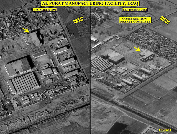
Image 6 shows changes in the status
of the Al Furat facility between December 1998 and September 2002.
Construction of the building in the image was suspended in 1991
and resumed in 2001. The building was originally intended to house
a centrifuge enrichment cascade operation supporting Iraq's uranium
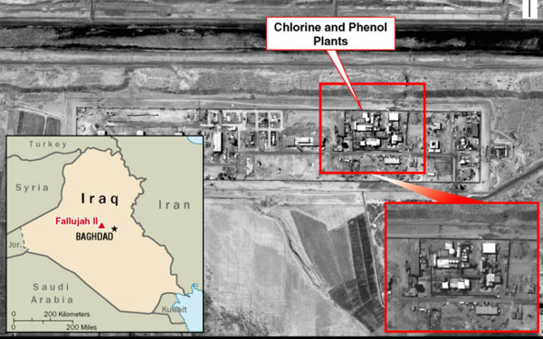
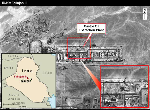
enrichment program. (Note 7) Image
7 and Image 8 are of two
components of a facility at Habbaniyah, located about 36 miles
northwest of Baghdad. Fallujah II was one of Iraq's principal
chemical weapons precursor facilities before the Gulf War. In
2000 and 2001, intelligence reports indicated that Iraq upgraded
the facility and brought in new chemical reactor vessels and shipping
containers with a large amount of production equipment. The Fallujah
III Castor Oil Production Plant (Image 8) was described by the
CIA as "situated on a large complex with an historical connection
to Iraq's CW program" and also of concern with respect to
its biological weapons potential. Image
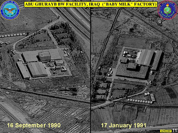
9 is the "Abu Ghurayb BW Facility," which Iraq
claimed was a baby milk factory. U.S. intelligence had classified
it as biological warfare facility since 1988, and Image 9 is one
of several (including some from commercial satellites) presented
in the DoD briefing in October 2002 on Iraqi denial and deception.
(Note 8)
Image 6: Al Furat Manufacturing Facility
Image 7: Fallujah II
Image 8 : Fallujah III
Image 9: Abu Ghurayb BW Facility
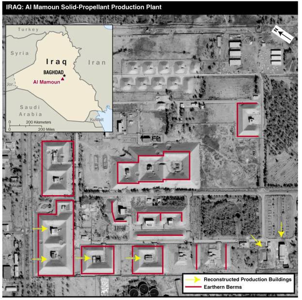
The next three images concern Iraqi missile activities. The image
(Image 10) of the Al Mamoun plant,
the CIA reported, showed that "the Iraqis ... have rebuilt
structures damaged during the Gulf War and dismantled by UNSCOM
that originally were built to manufacture propellant motors for
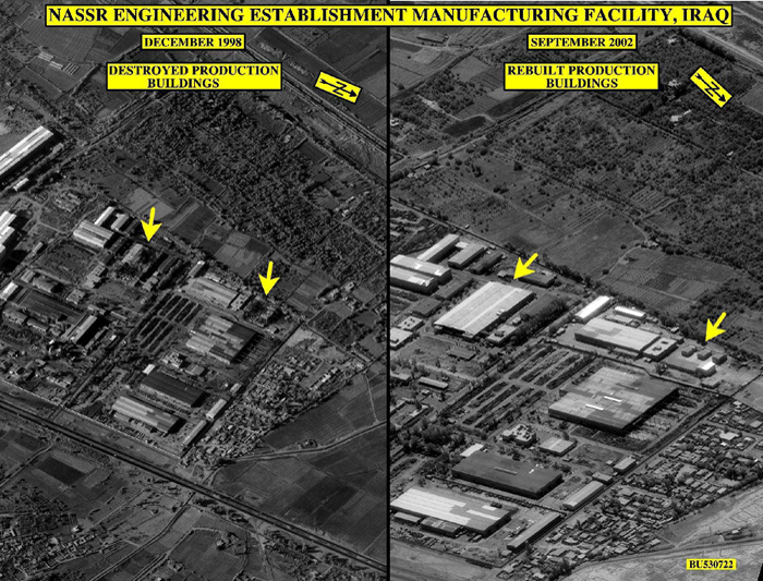
the Badr-2000 program." The Nassr Engineering Establishment
Manufacturing Facility, shown in Image 11,
was destroyed during Operation Desert Fox. It had produced centrifuge
and electro-magnetic isotope separation components prior to Desert
Storm, according to the IAEA. Imagery interpreters concluded that
the right portion of the image shows the "subsequent reconstruction
of machining buildings assessed to be capable of producing precision
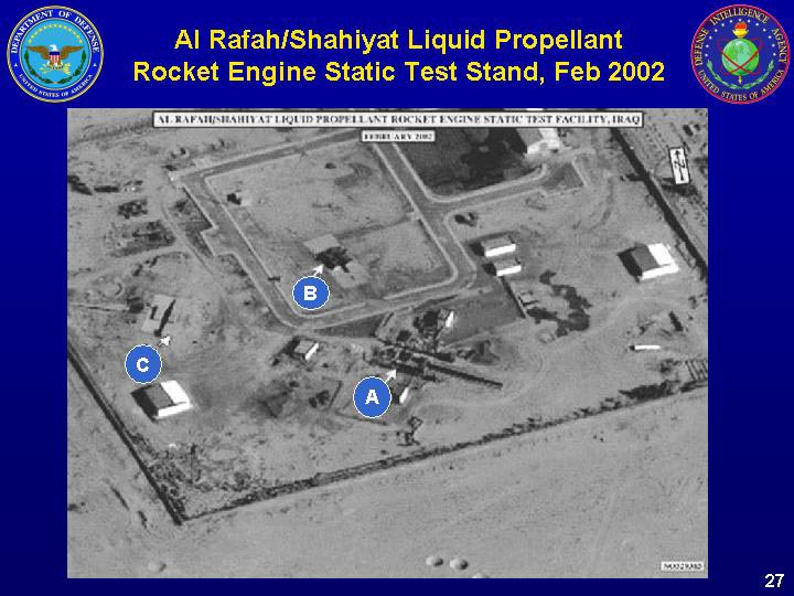
components for centrifuges and missiles." Image
12 was described by John Yurechko, the DIA Defense Intelligence
Officer for Information Operations and Denial and Deception, as
indicating testing facilities for both short-range missiles and
a missile with a much greater range, and noted that "Iraq
recently has taken some measures to conceal some of the activities
at this site." (Note 9)
Image 10: Al Mamoun Solid-Propellant
Plant
Image 11: Nassr Engineering Establishment
Manufacturing Facility
Image 12: Al Rafah/Shayit Test Stand
On February 5, 2003 Secretary of State Colin Powell addressed
the U.N. Security Council on the issue of Iraq and disarmament.
He presented a combination of imagery and signals intelligence
intended to persuade the council members and others that Iraq
had not disarmed and was seeking to deceive the U.N. and its inspectors.
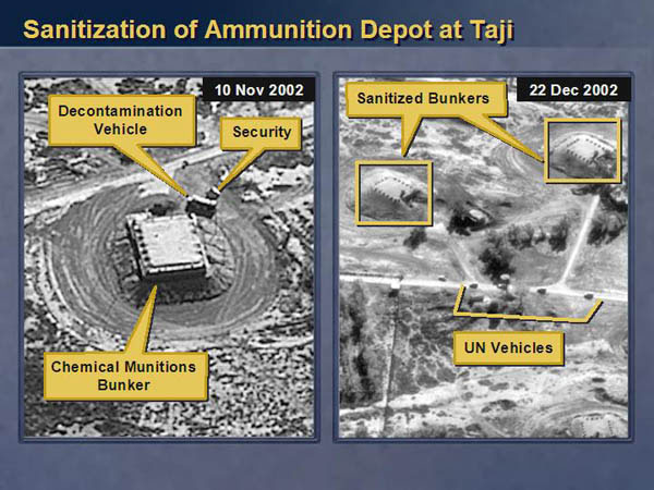
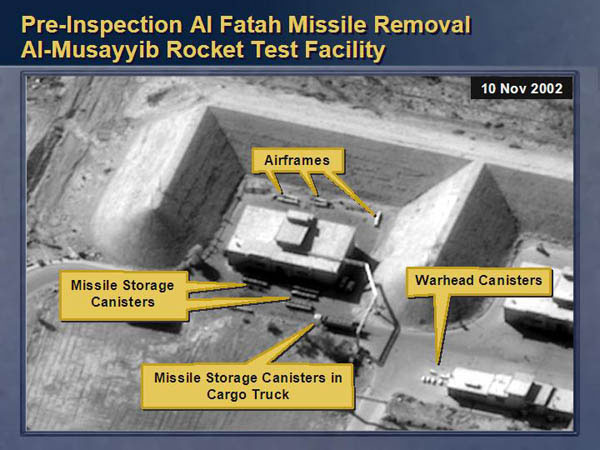
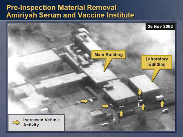
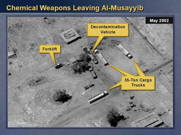
The imagery presented (images 13-16 below), Powell stated, provided
evidence of Iraq's failure - including images of sanitization
of ammunition dumps, and of chemical weapons being moved from
a storage site.
Thus, Image 13, Powell charged,
showed unmistakable signs of arrangements associated with a chemical
weapons facility - a security bunker and a decontamination vehicle.
Image 14, showed a cargo truck preparing
to move missile components, according to Powell, while Image
15 showed a truck caravan appearing two days before inspection
resumed, a caravan "we almost never see at this facility."
The final image, obtained in May 2002, (Image
16) shows trucks at the Al Mussayyib chemical complex
along with a decontamination vehicle. Powell reported that human
intelligence reporting confirmed that "movement of chemical
weapons occurred at this site at this time." (Note
10)
Image 13: Sanitization of Ammunition
Dump at Taji
Image 14: Pre-inspection: Al Fatah Missile
Removal
Image 15: Pre-inspection: Material Removal,
Amiryah Serum and Vaccine Institute
Image 16: Chemical weapons leaving Al-Musayyib
Other Military
Sites
The great majority of the imagery released of terrorist and other
military sites in Iraq was released as part of Defense Department
or Central Command briefings after the beginning of hostilities.
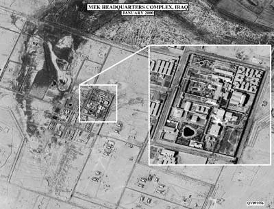
The exceptions (images 17-18) concern terrorist facilities. Image
17 shows the headquarters of the Mujahedin-e-Khalq (MEK),
also known as the National Liberation Army of Iran and classified
as a terrorist group by the State Department, which describes
it as "following a philosophy that mixes Marxism and Islam,"
and having "developed into the largest and most active armed
Iranian dissident group." The group maintains both tanks
and artillery on the border with Iran. As part of the 2003 Gulf
War military operation, the U.S. bombed the bases of the MEK.
(Note 11)
Image 18 was shown to the U.N.
Security Council during Colin Powell's February 5, 2003 presentation.
Powell described it as showing a terrorist poison and explosive
factory in Iraq, operated by an Islamic terrorist group, Ansar
al-Islam, with ties to Al-Qaeda. Image 19
and Image 20 show the status of
the camp before and after air strikes in late March. At a Pentagon
briefing General Richard Myers described image 20 as an "image
of the former terrorist camp - training camp at Khurmal"
and went on to say that "I stress 'former' since it is no
longer an active terrorist camp. We struck this camp in northeastern
Iraq early last week with several dozen Tomahawk missiles and
precision air strikes ..." (Note 12)
Image 17: MEK Headquarters Complex
Image 18: Terrorist Poison and Explosive
Factory
Image 19: Terrorist Camp - Pre Strike
Image 20: Terrorist Camp - Post Strike
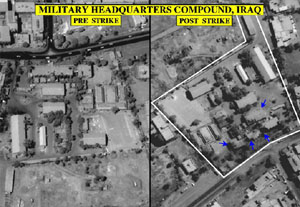
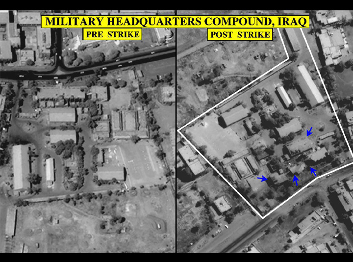
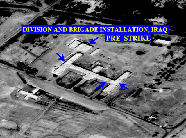
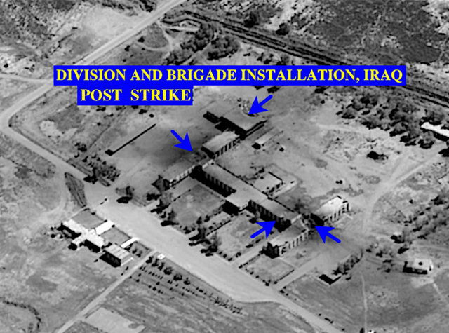
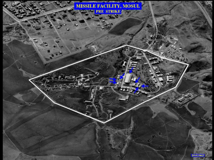
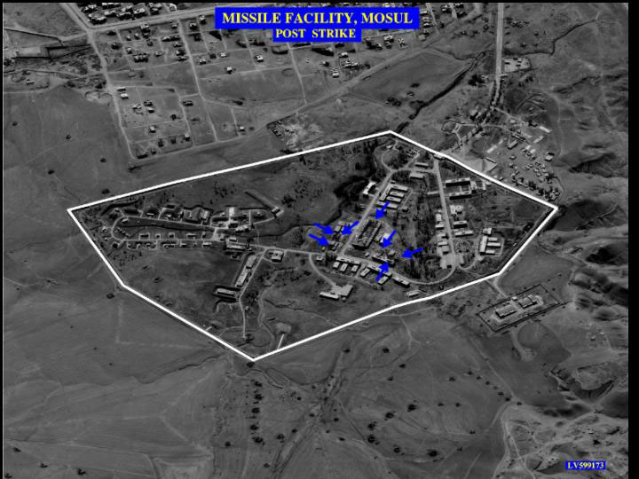
The remaining images represent pre-and post- strike of a military
headquarters compound (Image 21),
a division and brigade installation (Image
22 and Image 23), and a
missile facility at Mosul (Image 24
and Image 25).
Image 21: Military Headquarters
Compound - Pre & Post Strike
Image 22: Division and Bridge Installation
- Pre Strike
Image 23: Division and Brigade Installation
- Post Strike
Image 24: Missile Facility, Mosul - Pre
Strike
Image 25: Missile Facility, Mosul - Post
Strike
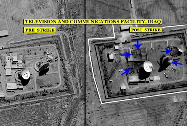
Command, Control, and Communications
A prime objective of the coalition strategy in the war was to
decapitate the Iraqi regime - as illustrated by the March 19 attack
on a facility where it had been reported that Saddam Hussein and
his sons were located. (Note 13) In addition
to seeking to eliminate the primary leadership of the Iraqi regime,
in the expectation that their deaths would severely reduce the
ability to the Iraqi military and security forces to resist coalition
military activities, the coalition also targeted command, control,
and communication (C3) facilities - so that even if Iraqi leaders
survived the attacks they, and their key subordinates, would be
unable to exercise coherent command of their forces.
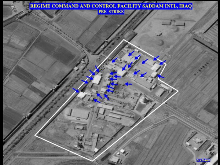
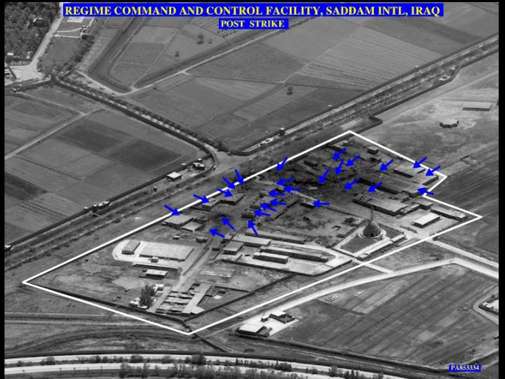
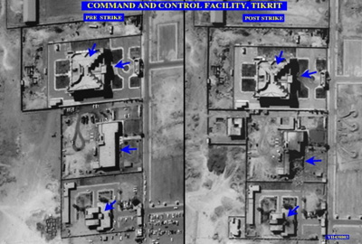
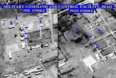
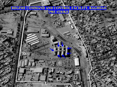
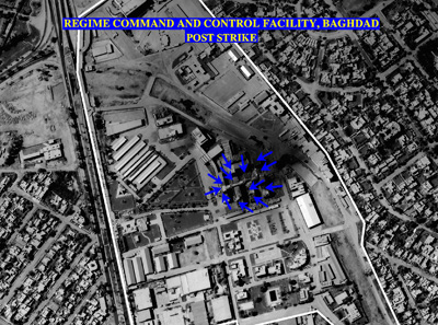
The images below represent pre- and post-strike images of regime
C3 facilities at a number of locations - Saddam International
Airport, Baghdad, and Tikrit.
Image 26: TV & Communications Facility:
- Pre & Post- Strike
Image 27: Regime Command and Control
Facility Saddam International Airport: Pre-Strike
Image 28: Regime Command and Control
Facility, Saddam International Airport: Post-Strike
Image 29: Command and Control Facility,
Tikrit: Pre & Post- Strike
Image 30: Military Command and Control
Facility: Pre & Post-Strike
Image 31: Regime Command and Control
Facility, Baghdad: Pre-Strike
Image 32: Regime Command and Control
Facility, Baghdad: Post-Strike
Security
and Intelligence Facilities
A key element of the ability of the Iraqi regime to survive was
its extensive use of security and intelligence organizations.
Indeed, the regime maintained five different such organizations
which were involved in intelligence collection, denial and deception
activities, acquisition of prohibited weapons material, suppression
of dissent, and counterintelligence. The organizations were also
used to watch each other, to prevent them from supporting a coup.
(Note 14)
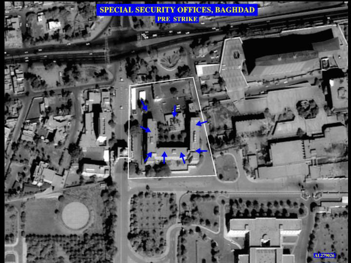
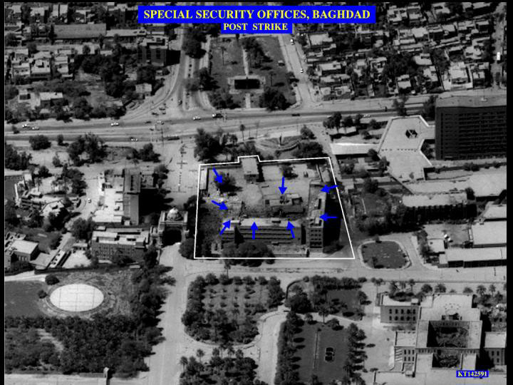
The images below represent pre- and post-strike images on two
of the most important of these organizations - the Special Security
Organization and the Iraqi Intelligence Service. The Special Security
Organization (SSO) was headed since 1992 by Saddam's son, Qusay,
and had 5,000 members. Its responsibilities included providing
presidential security, securing presidential facilities, supervising
other security and intelligence organizations, monitoring government
ministries and the leadership of the armed forces, supervising
internal security operations against Kurdish and Shi'a opposition,
purchasing foreign arms and technology, and directing efforts
to conceal Iraqi WMD programs. (Note 15)
Image 33: SSO, Baghdad, Pre-Strike
Image 34: SSO, Baghdad, Post-Strike
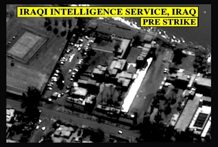
The Iraqi Intelligence Service (al Mukhabarat) or General Intelligence
was partially an internal agency. Its functions included, but
were not limited to, monitoring the Ba'ath Party, counterespionage,
eliminating opposition to the regime, monitoring foreign embassies
in Iraq, monitoring foreigners in Iraq. (Note 16)
Image 35: Iraqi Intelligence Service,
Baghdad - Pre strike
Image 36: Iraqi Intelligence Service,
Baghdad - Post strike
Civilian Sites
Imagery of civilian areas was used to illustrate three arguments
made by the Bush administration - Iraqi deception with regard
to matters in addition to WMD, its attempts to use civilian and
civilian areas as shields to prevent attacks on military equipment,
and its willingness to extinguish groups considered a threat to
the regime. Most of the imagery below (images 38-43) were released
as part of pre-war publications or a DoD briefing.
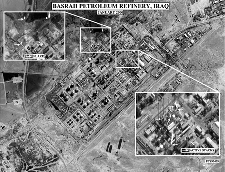
One image (Image 37) is a pre-war
image of the petroleum facility at Basrah - Iraq's second largest
city and a key coalition objective.
Image 37: Basrah Petroleum Refinery
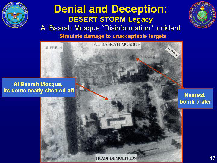
One image relates to Iraqi charges from the 1991 Persian Gulf
War that allied forces had bombed a mosque - the top of which
U.S. imagery (Image 38) shows to
have been cleanly cut off.
The State Department's Apparatus of Lies reports that
the dome was deliberately removed on February 11, 1991 and points
out that there was no damage to the area surrounding the dome.
(Note 17)
Image 38: Al Basrah Mosque
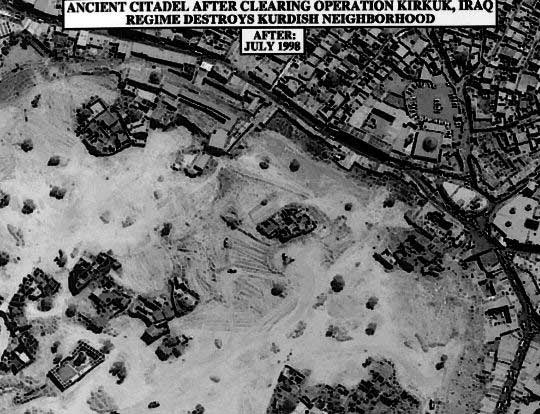
Another two images (Image 39 and
Image 40) show the ancient citadel
at Kirkuk before and after Iraqi military operations devastated
the area. According to a 1999 State Department publication, Saddam
Hussein's Iraq: "in the 1970s and 1980s, the Iraqi regime
destroyed over 3,000 Kurdish villages. The destruction Kurdish
and Turkomen homes is still going on ... as evidenced [by] the
destruction by Iraqi forces of civilian homes in the citadel of
Kirkuk." (Note 18)
Image 39: Ancient citadel before clearing
operation Kirkuk, Iraq; Regime Destroys
Kurdish Neighborhood (Before: September 1997)
Image 40: Ancient citadel before clearing
operation Kirkuk, Iraq; Regime Destroys
Kurdish Neighborhood (After: July 1998)
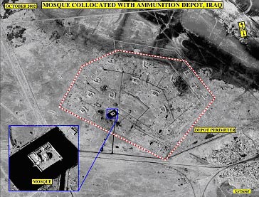
Three images (41, 42
and 43) show military equipment
dispersed to civilian locations - including a mosque, a historical
site, and a water treatment facility.
Image 41: Mosque collocated with ammunition
depot, Iraq
Image 42: Military Aircraft dispersed
during Operation Desert Storm to Historical
Site Near Tallil, Iraq
Image 43: Water Treatment Facility (SRBM
Hide site): Pre & Post- Strike
Notes
1. See William E. Burrows, Deep Black: Space
Espionage and National Security (New York: Random House, 1986).
2. Jeffrey T. Richelson, The U.S. Intelligence
Community (Boulder, Co.: Westview, 1999), pp. 150-179.
3. Dwayne A. Day, John M. Logsdon, and Brian
Latell (eds.), Eye in the Sky: The Story of the Corona Spy
Satellites (Washington, D.C.: Smithsonian, 1998), pp. 1-21.
4. The imagery is archived on the DoD web site
- http://www.defenselink.mil.
Some of the imagery can be found in the National Security Archive
briefing book, U.S.
Satellite Imagery, 1960-1999, April 14, 1999.
5. "Inside Baghdad," Time, March
14, 2003, pp. 58-59; "Pinpointing Baghdad," Time,
March 31, 2003, pp. 48-49; "With Nothing Left, Looters blow
up the fish in Saddam's ponds," April 15, 2003, http://www.seafood.com;
"Photos bolster U.S. campaign against Iraq's Hussein,"
September 14, 1999, http://www.cnn.com;
U.S. Department of State, Saddam
Hussein's Iraq (Washington, D.C., 1999), not paginated.
6. Central Intelligence Agency, Iraq's Weapons
of Mass Destruction Programs, (Washington, D.C: CIA, 2002);
DoD, Iraqi Denial and Deception for Weapons of Mass Destruction
& Ballistic Missile Programs, October 8, 2002, http://www.defenselink.mil;
President George W. Bush, "Remarks by the President on Iraq,
Cincinnati Museum Center - Cincinnati Union Terminal," October
7, 2002, http://www.whitehouse.gov.
7. "Declassified intelligence photos of
Iraqi nuclear weapons-related facilities/Al Furat," October
9, 2002, http://brownback.senate.gov.
8. "Fallujah/Habbaniyah,"
http://www.globalsecurity.org; Central Intelligence Agency,
Iraq's Weapons of Mass Destruction Programs, p.11; DoD, Iraqi
Denial and Deception for Weapons of Mass Destruction & Ballistic
Missile Programs, slide 14; "Abu Ghurabyb, Project 600,"
http://www.fas.org.
9. Central Intelligence Agency, Iraq's Weapons
of Mass Destruction Programs, p.21; "Declassified intelligence
photos of Iraqi nuclear weapons-related programs/Nassr,"
October 9, 2002, http://brownback.senate.gov;
Dr. John Yurechko, "DoD Briefing on Iraqi Denial and Deception,"
October 8, 2002, p. 10. http://www.defenselink.mil.
10. Secretary Colin L. Powell, "Remarks
to the United Nations Security Council," February 5, 2003,
http://www.state.gov, pp. 5-6,
11-12.
11. U.S. Department of State, Patterns of
Global Terrorism (Washington, D.C.: U.S. Government Printing
Office, 2001), p. 65; Douglas Jehl, "U.S. Bombs Iranian Guerilla
Forces Based in Iraq," New York Times, April 17, 2003,
pp. B1, B2.
12. Secretary of State Colin L. Powell, "Failing
to Disarm," Presentation to the UN Security Council, February
5, 2003, http://www.state.gov;
Secretary of Defense Donald Rumseld and General Richard Myers,
"DoD News Briefing, April 1, 2003," http://www.defenselink.mil
.
13. Evan Thomas and Daniel Klaidman, "The
War Room," Newsweek, March 31, 2003, pp. 22-31.
14. Ibrahim al-Marashi, "Iraq's Security
and Intelligence Network: A Guide and Analysis," Middle
East Review of International Affairs 6, 3 (September 2003),
pp. 1-13.
15. Ibid., p.3.
16. Ibid, pp. 5-6; see also Melinda Liu, Rob
Nordland, and Evan Thomas, "The Saddam Files," Newsweek,
April 28, 2003.
17. U.S. Department of State, Apparatus of
Lies: Saddam's Disinformation and Propaganda, 1990-2003 (Washington,
D.C.: 2003), p. 25.
18. U.S. Department of State, Saddam
Hussein's Iraq, not paginated.
